Map 1
Camera filenames are provisionally interpreted as UTC. ERA5 times are UTC. Matching remains provisional until the camera clock is confirmed.
Settings · saved setups & export
Setups are saved in this browser. Reset restores the initial view and pauses playback; saved setups and source data are preserved.
PNG export covers the Map 1 / Map 2 comparison with legends. Available for Boundaries and Black; live web basemaps require a browser screenshot to preserve licensed tiles. Setup JSON contains view settings only, not imagery or credentials.
Map 1 / Map 2 comparison
ERA5 sampled cellsWind-speed shading shows native 0.25° ERA5 cells; other scalars currently show sampled cell-centre symbols, not interpolated fields. Outlined dots mark camera stations. Link map views controls spatial synchronization independently of data time. Data times follow the camera UTC hour by default; independent map times is an explicit option. Visible and thermal Himawari fields remain unavailable until processed.
Camera originals & station locator
Sky camera
Fixed empirical tint correction. Original files are preserved.
Coast to mountain
5 stationsBAM-Net coordinates supplied by Dariusz Baranowski. Click a numbered station to select it. EAR is a separate site farther north.
Hourly ERA5 context
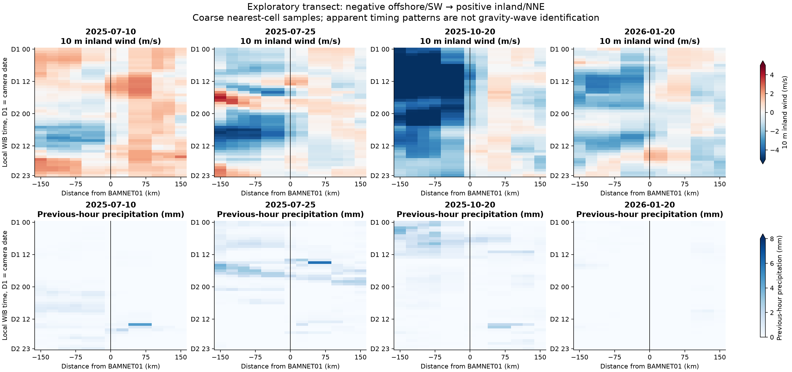
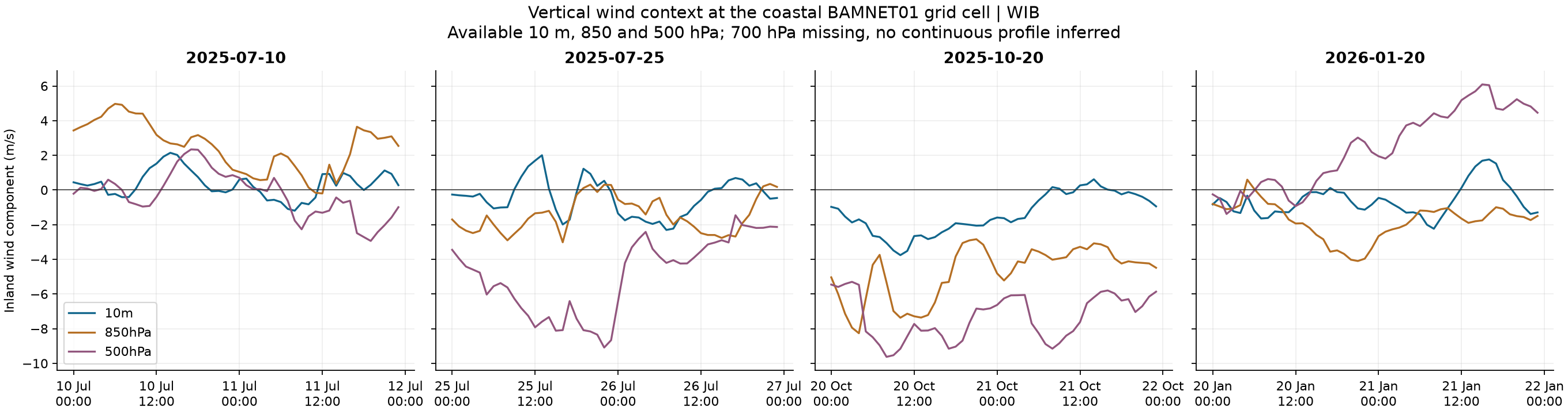
Hourly model reanalysis on a 0.25° grid: BAMNET02/03 share one cell; BAMNET04/05 share another. Inland wind is positive toward the northeast (45°). Each case covers local midnight through the following day. This cannot by itself distinguish a sea breeze from gravity waves.
Himawari · JAXA P-Tree
One scan loaded10 July 2025, 05:00 UTC nominal scan. Regional pixels observed approximately 05:04:38–05:06:03 UTC (12:04:38–12:06:03 WIB).
- B03 visible: reflectance × cos(solar zenith).
- B13 infrared: brightness temperature in K; bright pixels are colder.
Select either Himawari field on Map 1 or Map 2, with 10 July 2025 and 05:00 UTC. Both channels cover the full ERA5 Sumatra region and offshore islands, approximately 94.87–107.13°E, 7.13°S–6.13°N, on the native approximately 2 km grid.
Full-disk collection interval: 10 minutes (6 scans/hour). Only one scan is loaded here. Visible imagery requires daylight; infrared works day and night. Cloud parallax is not corrected. ERA5 OLR is available hourly on the same regional extent. Retrieved cloud-top height is not loaded.
JAXA P-Tree documentationSoundings & surface observations
Availability under reviewPadang Pariaman / Minangkabau
WMO 96163 · NOAA IGRA IDM00096163
Station metadata confirmed. Historical archive coverage extends through 2025 in the checked station list; individual camera-day soundings are not yet verified.
BMKG stations along the corridor and EAR wind profiles are additional candidates. They are not displayed as available observations until date-specific records are checked.
BMKG historical data · IGRA station metadataCamera projection · preliminary example
Camera 1 only. Three assumed cloud heights (1, 2 and 5 km above the camera). The solar fit is provisional; this is not a measurement of cloud location or cloud base. It is a fixed example, independent of the time selector.
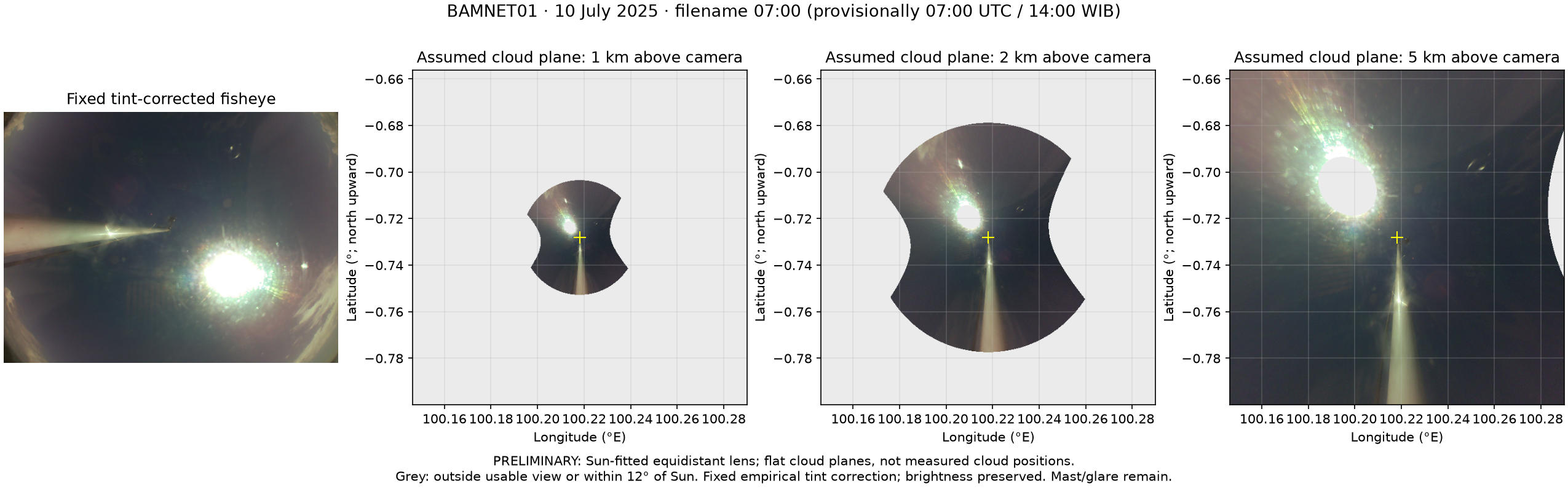
Click the overview to open it at its saved resolution.
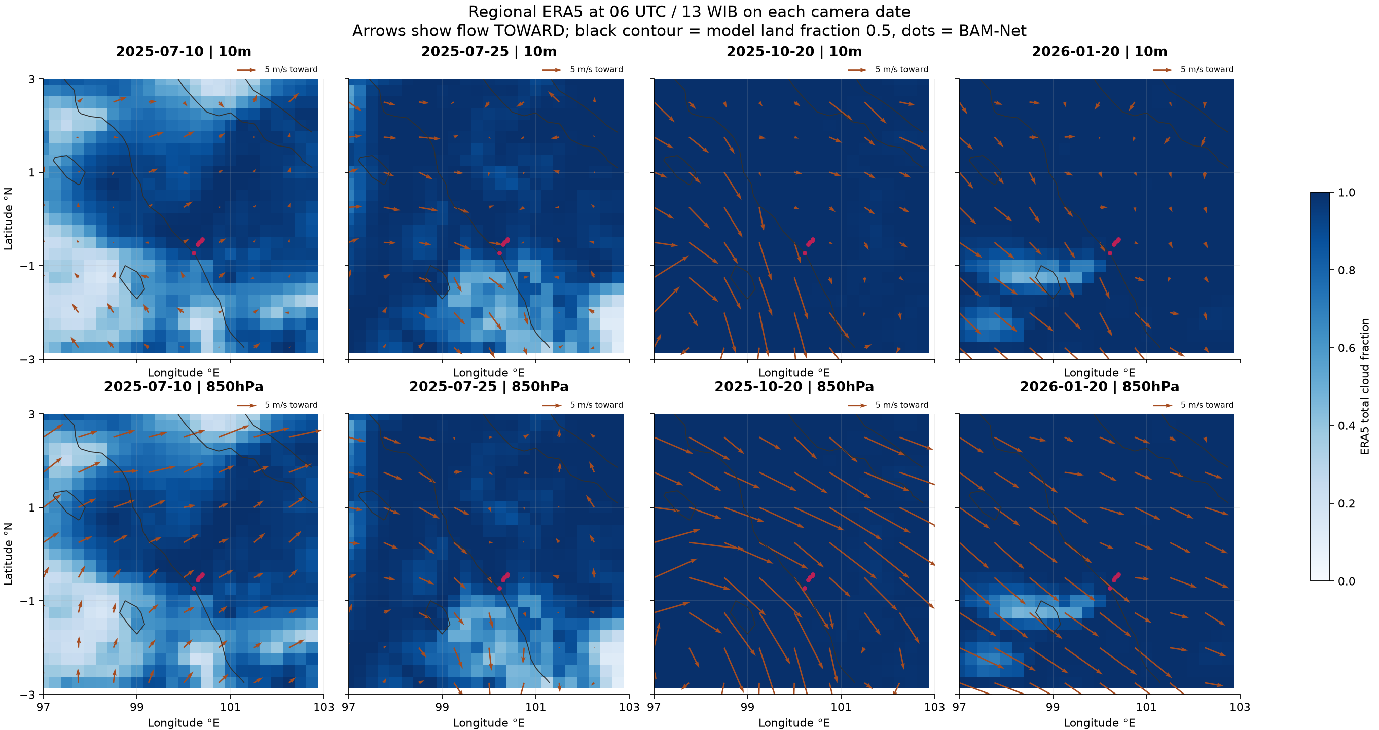
Regional ERA5 views · all four cases
These fixed summaries provide coast–mountain and vertical context. They do not change with the camera selector.
Sources, coverage & interpretation
Camera collection: 539 nonempty JPEG files across seven station/day sequences, plus three empty files omitted. One BAMNET02 image at 14:10 UTC on 20 January 2026 is flagged for inconsistent daylight and is excluded from time matching. Images are resized display derivatives; the originals are unchanged. Camera cloud fractions have not yet been computed. Sun glare, masts, droplets and colour distortion remain relevant.
ERA5: ECMWF/ERA5/HOURLY through Google Earth Engine. GEE extracted hourly station/grid values and derived wind components. Missing camera images do not imply clear sky; model cloud fraction and camera sky fraction are different quantities. Precipitation refers to the preceding hour. No 700 hPa data are included.
Geography: Natural Earth country boundaries provide generalized context, not a survey coastline. EAR metadata: RISH, Kyoto University. Current BMKG identifier 96163 names Minangkabau; the historical label “Padang/Tabing” must not be assumed to indicate the same location.